Garmin eTrex Vista Cx Handheld Navigator
Garmin Updated: 2008-09-16 RSS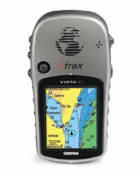
Pack more detail into your adventure with the eTrex Vista Cx. This popular handheld navigator has a bright color screen, barometric altimeter, electronic compass and microSD™ card for expandable memory, and it can route you on roads or off, for wherever your travels take you.
Expand Your Memory
Storing data is easier than ever with Vista Cx's included 64 megabyte (MB) microSD card. Just connect to your computer and load optional MapSource® software to view detailed maps of your surroundings. The card slot is located inside the waterproof battery compartment, so you don't have to worry about getting it wet. You can also use optional preloaded microSD cards with MapSource data for your land and sea excursions. Just insert a MapSource card with detailed street maps, and Vista Cx provides turn-by-turn directions to your destination.
Take It Anywhere
The Vista Cx has a built-in electronic compass that provides bearing information even while you're standing still, and its barometric altimeter tracks changes in pressure to pinpoint your precise altitude. You can even use the altimeter to plot barometric pressure over time, which can help you keep an eye on changing weather conditions. Like the rest of the eTrex series, the rugged Vista Cx is WAAS-compatible and waterproof, so it can withstand the elements or an accidental dunk in water.
Other Vista Cx features:
* 256-color, sunlight-readable display makes it easy to distinguish map details — plus, it looks fantastic
* Supports English, Spanish, Portuguese and French languages
* Extra-long battery life brings you more hours of outdoor enjoyment
* Fast USB computer connection so you can transfer waypoints and other data to your computer
eTrex Vista Cx: This little color navigator goes a long way
Physical & Performance:
Unit dimensions, WxHxD: 4.2" x 2.2" x 1.2" (10.7 x 5.6 x 3.0 cm)
Display size, WxH: 1.3" x 1.7" (3.3 x 4.3 cm)
Display resolution, WxH: 176 x 220 pixels
Display type: 256 level color TFT
Weight: 5.5 oz (156 g) with batteries
Battery: 2 AA batteries (not included)
Battery life: 32 hours
Waterproof: yes (IPX7)
Floats: no
High-sensitivity receiver: no
Interface: USB
RoHS version available: yes
Maps & Memory:
Basemap: yes
Preloaded maps: no
Ability to add maps: yes
Built-in memory: no
Accepts data cards: 64 MB microSD card (included)
Waypoints/favorites/locations: 500
Routes: 50
Track log: 10,000 points, 20 saved tracks
Features:
Automatic routing (turn by turn routing on roads): yes
Electronic compass: yes
Barometric altimeter: yes
Geocaching-friendly: yes
Outdoor GPS games: yes
Hunt/fish calendar: yes
Sun and moon information: yes
Tide tables: no
Area calculation: yes
Custom POIs (ability to add additional points of interest): yes
Unit-to-unit transfer (shares data wirelessly with similar units): no
Picture viewer: no
Spec Sheet
Owners Manual
Quick Reference Guide
Declaration of Conformity
Related Manuals
Garmin eTrex Vista C Handheld Navigator
Garmin Geko 101 Personal Navigator
Garmin GPS II Mapping GPS Receiver
Garmin GPS II Plus Mapping GPS Receiver
Garmin GPS III Mapping GPS Receiver
Garmin GPS III Plus Mapping GPS Receiver
Garmin GPS 12 Personal Navigator
Garmin GPS 12CX Personal Navigator
Garmin GPS 12MAP Personal Navigator
Garmin GPS 12XL Personal Navigator
Garmin GPSMAP 60C Handheld GPS Receiver
Garmin GPSMAP 60CS Handheld GPS Receiver