Garmin MX20 Color Multi-Function Display
Garmin Updated: 2008-09-15 RSS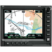
Offering an impressive list of features and nav graphic interfaces, the MX20 multi-function display is a fully integrated "big picture" pilot information center.
The MX20 MFD’s large active-matrix LCD display extends a full 6 inches diagonally, and its crisp 640 x 480-pixel screen offers the highest resolution in its class. At a glance, you can see your aircraft’s position and track on a VFR- or IFR-style navigation chart — with course lines, waypoints and flight progress displayed over realistic terrain depictions. For arrivals and departures, an exclusive ChartView™ option lets you confirm your aircraft’s position on Jeppesen® instrument approach plates and airport surface charts. A unique split-screen feature enables side-by-side displays of any two MX charting functions.
Added safety is provided by a built-in terrain elevation database that color codes relevant ground features in relation to your aircraft altitude, alerting you as you approach rising terrain. The MX20 will also integrate with various onboard weather radar, lightning, traffic awareness and datalink systems that enable uploading of real-time graphical weather information and NEXRAD radar depictions.
In addition, the MX20's custom map function is customizable. This lets you create a display for almost any configuration you require, offering extensive overlay capabilites. Other functions provide more limited levels of customization, retaining the look and feel of the instruments they reflect — an important safety feature.
You can interface the MX20 with most manufacturers’ GPS navigation equipment. And when coupled to Garmin GPS and VHF nav systems, the MX20 provides extra features and levels of convenience that exceed those of systems costing many times more. No wonder pilots are choosing MX20 displays when they upgrade their avionics or purchase a new aircraft.
Please note:
* MX 20 Standard = Not compatible with Traffic Systems, Onboard Radar Systems
or EGPWS. See MX20 I/O Traffic or MX 20 I/O Traffic & Radar.
* MX 20 I/O Traffic = Not compatible with Onboard Radar Systems or EGPWS. See
MX 20 I/O Traffic & Radar.
* MX 20 I/O Traffic & Radar = Contact Technical Support for list of compatible
Radar Systems.
ChartView Option
With the exclusive ChartView option, instrument approaches and airport surface diagrams can be viewed on the MX20, with the aircraft position overlaid on familiar JeppView chart depictions. Standard Instrument Departure and Arrival charts (DPs and STARs) are also provided.
Split-Screen Feature
For multi-view situational reference, the latest MX20 software offers a unique split-screen feature, allowing side-by-side displays of any two MX20 charting functions. In addition, a vertical profile view of terrain peaks and obstructions relative to the current flight level can be displayed across the lower portion of the screen.
Pilots Guide
Quick Reference Guide
Related Manuals
Garmin Apollo GX65 GPS Receiver
Sony NV-U94T Portable Satellite Navigation System
Sony NV-U84 Portable Satellite Navigation System
Sony NV-U44 Portable Satellite Navigation System
Motorola T815 Bluetooth Phone Based Navigation System
Panasonic CN-GP50U Mobile Navigation System
Pioneer AVIC-F90BT Premier In-Dash Navigation AV Receiver
Pioneer AVIC-F900BT In-Dash Navigation AV Receiver
Pioneer AVIC-F700BT In-Dash Navigation AV Receiver
Pioneer AVIC-F500BT Navigation
Pioneer AVIC-Z3 Powerful HDD Navigation
Pioneer AVIC-N4 In-Dash DVD Multimedia Navigation Receiver