Garmin GPSMAP 430/430s Chartplotter
Garmin Updated: 2008-09-17 RSS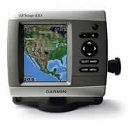
This sleek, space-saving chartplotter is your companion for freshwater fishing and boating. The GPSMAP 430 features preloaded detailed maps for U.S. inland lakes as well as an ultra-bright 4" QVGA display; built-in, satellite-enhanced worldwide basemap and simplified user operation.
Navigate Any Lake
The 430 comes preloaded with detailed maps for U.S. inland lakes, including 5300 lakes with shoreline, depth contours, navaids and more. Over 300 of these lakes are enhanced with extra Inland Lakes Vision features (see below). For areas outside the U.S., the 430 has a worldwide basemap with satellite images in place of more traditional maps, and its SD™ card slot makes it easy to add additional maps without connecting to a computer. With fewer keys and a simple, intuitive interface, the 430 makes navigating your way through the water easy.
The 430 boasts advanced Inland Lakes Vision features for 300 of the most popular lakes.
* 3D mariner's eye view or fish eye view provides you with a 3-dimensional perspective of map information, both above the waterline and below it.
* Higher-resolution satellite images help you orient yourself in unfamiliar areas.
* Auto guidance technology searches through map data to suggest the best passage.
Add Sonar and Weather
The sounder version, GPSMAP 430s, comes with a dual beam transducer that clearly paints depth contours, fish targets and structure. It's also CANet™ compatible, so you can share sounder data with another chartplotter on your boat. The weather-enabled versions, GPSMAP 430x and 430sx, display XM satellite weather data, including NEXRAD radar, with the GXM 31 antenna.
Add Extras with BlueChart® g2 Vision
With the optional BlueChart g2 Vision SD card, you can add a whole new dimension of exceptional features to your chartplotter for offshore use, including advanced 3D perspective, Auto guidance, high-resolution satellite images, detailed fishing charts and more.
Owners Manual
Quick Reference Guide
Template
Flush Mount Kit Instructions (multilingual)
Related Manuals
Garmin GPSMAP 420/420s Chartplotter
Garmin GPSMAP 440/440s Chartplotter
Garmin GPSMAP 520/520s Chartplotter
Garmin GPSMAP 530/530s Chartplotter
Garmin GPSMAP 540/540s Chartplotter
Garmin GPSMAP 525/525s Chartplotter
Garmin GPSMAP 535/535s Chartplotter
Garmin GPSMAP 545/545s Chartplotter
Garmin GPSMAP 276C Chartplotter
Garmin GPSMAP 376C Chartplotter
Garmin GPSMAP 278 Chartplotter
Garmin GPSMAP 378 Chartplotter