Garmin GPSMAP 396 Portable Aviation Receiver
Garmin Updated: 2008-09-15 RSS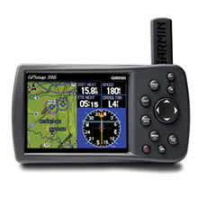
See the big picture, including weather, with the GPSMAP 396. Building on the success of the 296, this aviation portable combines a color map and terrain alerting with XM WX Satellite Weather.
Enhance Situational Awareness
GPSMAP 396 comes with a detailed built-in Jeppesen® database along with terrain and U.S. obstacles databases. Using this information, the 396 provides detailed views of your flight route, displayed over realistic topography. For added safety, you can put the unit in Terrain mode for TAWS-like warnings and alerts when proximity conflicts loom ahead.
View Images in Sharp Detail
Viewing the display in any light is easy, thanks to the unit's 256-color, high-resolution (320 x 480-pixel) sunlight-readable TFT display with adjustable backlighting. The 396 also features USB data transfer, fast processing speed and a rechargeable lithium-ion battery pack.
Add Weather, Radio and Traffic
Make informed decisions based on weather and traffic with optional sensors and services. With a subscription to XM WX Satellite Weather and the included GXM 30A smart antenna, you'll have access to constantly-updated, high-resolution weather data for the U.S., right in the cockpit. Weather information includes Next Generation Radar (NEXRAD), Aviation Routine Weather Reports (METARs), Terminal Aerodrome Forecasts (TAFs), Temporary Flight Restrictions (TFRs), Lightning and Winds Aloft and can be laid directly over the 396's map. With an additional monthly service fee, GXM 30A delivers XM Satellite Radio to your aircraft. Add a Garmin Mode S transponder, and the 396 can display TIS traffic alerts that identify surrounding air traffic.
Automate Your Logbook
A built-in logbook tracks your flying hours and automatically records departure and arrival locations. When used with Garmin's free logbook software, FlightBook, this feature simplifies record keeping. Flightbook software allows you to create, manage, analyze, save and print flight data from GPSMAP 396's logbook.
Navigate by Air, Land or Sea
Simply press a button to switch GPSMAP 396 to automotive or marine mode. The 396 comes with a built-in routable basemap. Add optional MapSource® detailed street maps and receive voice-prompted turn-by-turn directions to addresses and points of interest. For a great day on the water, customize the waterproof 396 with optional marine cartography. Easily add detailed maps with plug and play Garmin data cards.
GPSMAP 396: Go from plane to boat to automobile without missing a beat.
Spec Sheet
Owners Manual
Quick Reference Guide
GA 26C Installation Instructions
GXM 30 Owners Manual for Marine/Aviation Products
Yoke Mount Instructions
Related Manuals
Garmin GPSMAP 296 Portable Aviation Receiver
Garmin GPSMAP 495 Portable Aviation Receiver
Garmin GPSMAP 496 Portable Aviation Receiver
Garmin GDL 90 ADS-B Datalink Transceiver
Garmin GDL 69 Remote Datalink Receiver
Garmin GRC 10 Remote Control
Garmin GRT 10 Transceiver
Garmin GAD 42 Interface Transponder
Garmin GTX 32 Interface Transponder
Garmin GTX 33 Interface Transponder
Garmin CNX 80 WAAS/GPS Navigator
Garmin GDL 49 Satellite Data Link Transceiver