Garmin GPSMAP 296 Portable Aviation Receiver
Garmin Updated: 2008-09-15 RSS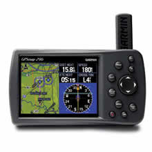
Taking terrain awareness to a whole new level, the GPSMAP 296 is a color aviation portable with built-in terrain mapping and alerting.
Enhance Situational Awareness
GPSMAP 296 comes with a detailed built-in Jeppesen® database along with terrain and U.S. obstacle databases. Using this information, the 296 provides detailed views of your flight route, displayed over realistic topography. For added safety, you can put the unit in Terrain mode for TAWS-like warnings and alerts when proximity conflicts loom ahead.
View Images in Sharp Detail
Viewing the display in any light is easy, thanks to the unit’s 256-color, high-resolution (320 x 480-pixel) sunlight-readable TFT display with adjustable backlighting. The 296 also features USB data transfer, fast processing speed and a rechargeable lithium-ion battery pack.
Automate Your Logbook
A built-in logbook tracks your flying hours and automatically records departure and arrival locations. When used with Garmin's free logbook software, FlightBook, this feature simplifies recordkeeping. Flightbook software allows you to create, manage, analyze, save and print flight data from the GPSMAP 296's logbook.
Navigate by Air, Land or Sea
Simply press a button to switch GPSMAP 296 to automotive or marine mode. The 296 comes with a built-in routable basemap. Add optional MapSource® detailed street maps to receive voice-prompted turn-by-turn directions to addresses and points of interest. For a great day on the water, customize the waterproof 296 with optional marine cartography. Easily add detailed maps with plug and play Garmin data cards.
GPSMAP 296: Go from plane to boat to automobile without missing a beat.
* WAAS-capable GPS receiver for enhanced lateral/vertical guidance
* Crisp, high-resolution display (480 x 320 pixel count), 256-color TFT display (3.8 inches diagonally)
* 200-MHz processor for fast redraw and routing
* Up to 15 hours battery life (typical use backlight conditions); 8 hours full backlight brightness
* Rechargeable lithium-ion battery pack
* Automotive and marine modes for easy navigation in a vehicle or boat
* Detailed basemap includes highways, major roads, borders, rivers, lakes and tide stations
* Accepts standard Garmin MapSource products
* 50 reversible routes (300 waypoints each), 15 saved tracks (700 trackpoints each), TracBack® technology, 3000 waypoints with graphical icon identification
* Adjustable quad-helix receiving antenna with remote antenna capability
* Voice prompt guidance when the 12-volt / speaker cable is connected
* Separate serial and USB interfaces; 2 RS-232 serial ports
* Adjustable yoke mount
* Full Jeppesen aviation database, including instrument approaches
* Terrain/obstacle display with pop-up warnings
* Built-in basemap with automatic routing and turn-by-turn directions
* Display: 3.8" diagonal, 256-color; 480 x 320 pixels
* Size: 5.7" W x 3.2" H x 1.9" D
* Weight: Just 12 ounces
Spec Sheet
Pilots Guide
Quick Reference Guide
Declaration of Conformity
FlightBook Quick Start Guide
GA 26C Installation Instructions
Yoke Mount Instructions
Related Manuals
Garmin GPSMAP 196 Portable Aviation Receiver
Garmin GPSMAP 396 Portable Aviation Receiver
Garmin GPSMAP 495 Portable Aviation Receiver
Garmin GPSMAP 496 Portable Aviation Receiver
Garmin GDL 90 ADS-B Datalink Transceiver
Garmin GDL 69 Remote Datalink Receiver
Garmin GRC 10 Remote Control
Garmin GRT 10 Transceiver
Garmin GAD 42 Interface Transponder
Garmin GTX 32 Interface Transponder
Garmin GTX 33 Interface Transponder
Garmin CNX 80 WAAS/GPS Navigator