Garmin GPSMAP 295 GPS
Garmin Updated: 2008-09-15 RSS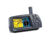
Mapping details on Garmin's GPSMAP 295 provide a clear picture of the ground below. Its big, 4-inch (diagonal) 16-color display makes it easy to distinguish SUAs from highways, or VORs from nearby towns. Move the cursor to one of those SUAs and the name, controlling agency, and vertical boundaries pop-up on the map. Meanwhile a "vector to final" feature offers the finest situational awareness on approach. This unit also can provide position accuracy to less than three meters when receiving WAAS corrections.
Like all Garmin portables, the GPSMAP 295 is pilot configurable. You can split the screen to keep an eye on an HSI graphic while tracking your progress on the moving map. You can also store up to 30 locations in a personal favorites list for quick access to those frequently traveled spots. Installation options are equally handy. Mount the 295 on the yoke for convenient one-thumb operation, or attach it to the glareshield in a heads-up configuration. Your choice.
Since the GPSMAP 295 is CD-ROM compatible, you also enjoy virtually unlimited mapping utility. Load city-specific data into your GPSMAP 295 from a MapSource® CD accessory, transfer the unit to your car, and you'll navigate to a restaurant on the ground as easily as you follow a flight plan in the air. The GPSMAP 295—brilliant GPS innovation. See it at a dealer (or cockpit) near you.
Pilots Guide
Quick Start Guide
Related Manuals
Garmin GPSMAP 195 Handheld
Garmin GTX 320 Transmitter
Garmin Apollo GX50 GPS Receiver
Garmin Apollo GX55 GPS Receiver
Garmin Apollo GX60 GPS Receiver
Garmin Apollo GX65 GPS Receiver
Garmin MX20 Color Multi-Function Display
Sony NV-U94T Portable Satellite Navigation System
Sony NV-U84 Portable Satellite Navigation System
Sony NV-U44 Portable Satellite Navigation System
Motorola T815 Bluetooth Phone Based Navigation System
Panasonic CN-GP50U Mobile Navigation System