Garmin GPSMAP 276C Chartplotter
Garmin Updated: 2008-09-17 RSS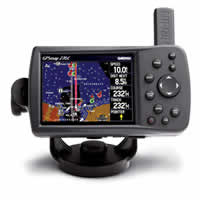
The GPSMAP 276C is a versatile color chartplotter and automobile navigator, perfect for land or water. Along with its counterpart, the GPSMAP 376C, this portable navigator features a sunlight-readable 256-color TFT display and a built-in autorouting basemap that can route you on major interstates and highways.
Head for the Water
On water, the GPSMAP 276C is a dependable color chartplotter with built-in basemap enhanced by Garmin's marine cartography. For extra-precise navigation, the 276C has a Course Deviation Indicator (CDI) — a feature normally found on aircraft, but equally practical for the marine environment. The CDI quickly indicates whether your boat has veered off-course and helps you get back on track quickly. The 276C also supports external NMEA sources for water depth, water temperature, and water speed through two serial interfaces.
Navigate on Land
On land, the GPSMAP 276C's autoroute basemap can route you on interstates and major highways. For even more detail, get the optional automotive kit (sold separately), which includes City Navigator® detailed maps, a data card and an automotive mount. With this kit, just load the detailed street maps on your 276C and pop it into the automotive mount for voice-prompted turn-by-turn directions to over six million addresses and points of interest, including restaurants, hotels, gas stations, marinas and other attractions.
Add More Marine Maps
The 276C is compatible with BlueChart® maps, which add extra detail when you're out on the seas. It also accepts optional MapSource® data cards, so you can add other types of map data easily. For convenience and easy map transfer, you can connect the 276C to your computer with the included USB cable.
GPSMAP 276C: The perfect navigator for water or land
Owners Manual
Quick Reference Guide
Related Manuals
Garmin GPSMAP 545/545s Chartplotter
Garmin GPSMAP 376C Chartplotter
Garmin GPSMAP 278 Chartplotter
Garmin GPSMAP 378 Chartplotter
Garmin GPSMAP 478 Chartplotter
Garmin GPS 152 Chartplotter
Garmin Fishfinder 400C Color Sounder
Garmin Fishfinder 300C Color Sounder
Garmin Fishfinder 160C Sonar
Garmin Fishfinder 140 Sonar
Garmin Fishfinder 90 Sonar
Garmin GMR 18 HD Radar