Garmin GPSMAP 2210 Color Chartplotter
Garmin Updated: 2008-09-17 RSS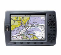
The GPSMAP 2210 and its counterpart, the GPSMAP 2206, bring you bold, sunlight-readable color, high-speed processing and preloaded detailed maps for the US coast.
Conquer the Coast
The GPSMAP 2210 comes preloaded with U.S. marine detailed maps for the entire coast of the United States, including Alaska and Hawaii. These maps are based on BlueChart g2 technology, so they layer smoothly and are integrated for easy panning, scrolling and zooming. The maps also provide a choice between 3D "mariner's-eye-view", or the familiar 2D direct-overhead view to make chart reading and orientation easier. And, with the GPSMAP 2210's large 10.4-inch diagonal screen, you'll get incredible contrast and detailing, even in direct sunlight.
Tough enough to withstand rain, sunlight and saltwater spray, the case is fully gasketed and waterproof to IPX7 standards. The 2210's slim-line design also makes it easy to install in cabin bulkheads or open cockpits. For added convenience, you can connect your 2210 to a sounder or other chartplotter with CANet®, Garmin's proprietary 1-megabit Controller Area Network that allows you to view and control sonar information from chartplotters located elsewhere in your boat.
Add More Marine Maps
The 2210 accepts optional BlueChart g2 data cards, which bring you 3D maps, tides and currents, depth contours, navaids, port plans, marine services, points of interest (POIs), photo references and more. Best of all, with these optional maps, you can view real, detailed aerial photos of harbors, marinas and other important marine landmarks and places, right on your chartplotter.
GPSMAP 2210: The coast is perfectly clear with the 2210
Owners Manual
GPSMAP 2206/2210 Installation Instructions
GPSMAP 2206/2210 Owners Manual
GPSMAP 2206/2210 Quick Reference Guide
Related Manuals
Garmin GPSMAP 2206 Color Chartplotter
Garmin GSD 20 Remote Sounder
Garmin nuvi 200 Portable GPS Navigator
Garmin nuvi 200W Portable GPS Navigator
Garmin nuvi 205 Portable GPS Navigator
Garmin nuvi 205W Portable GPS Navigator
Garmin nuvi 250 Portable GPS Navigator
Garmin nuvi 250W Portable GPS Navigator
Garmin nuvi 255 Portable GPS Navigator
Garmin nuvi 255W Portable GPS Navigator
Garmin nuvi 260 Portable GPS Navigator
Garmin nuvi 260W Portable GPS Navigator