Garmin GPSMAP 215 GPS Plotter
Garmin Updated: 2008-09-17 RSS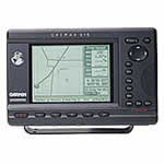
Take Garmin's successful GPS plotter and add the popular 12 parallel channel GPS receiver and optional built-in differential GPS (DGPS) receiver, and you've got the GPSMAP 215: a full-serve navigation package that's a snap to install in your nav station.
This unit uses the latest LCD technology to provide a 3-level gray image for sharp contrast. A 320 x 240 pixel screen provides high definition and a crystal-clear view of your precise location and surroundings. The GPSMAP 215 is available with a built-in DGPS receiver to receive and decode transmitted data from the U.S. Coast Guard's and the International Association of Lighthouse Authorities' public use beacon systems. This correction data is provided without user fees and reduces GPS system errors, including the Department of Defense-imposed Selective Availability.
Garmin GPSMAP systems are more than a pretty picture. Our Graphic User Interface guides you through informative navigation screens with true simplicity. A combination of interactive softkeys and single-function keys lets you go from mapping to text screens with just a touch. You'll also enjoy easy selection of commands right on screen, without complicated menus for navigation or setup. Garmin inland and Navionics offshore G-chart™ cartridges with wide area and seamless coverage complement a built-in worldwide basemap.
Spec Sheet
Owners Manual
Related Manuals
Garmin GPSMAP 210 GPS Plotter
Garmin GPSMAP 220 GPS Plotter
Garmin GPSMAP 225 GPS Plotter
Garmin GPSMAP 230 Sounder
Garmin GPSMAP 232 Sounder
Garmin GPSMAP 235 Sounder
Garmin GPSMAP 238 Sounder
Garmin GPSMAP 292 Sounder
Garmin GPSMAP 298 Sounder
Garmin GPSMAP 392 Sounder
Garmin GPSMAP 398 Sounder
Garmin GPSMAP 492 Sounder