Garmin GPSMAP 195 Handheld
Garmin Updated: 2008-09-15 RSS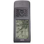
The Garmin GPSMAP 195 is aviation's largest display moving map handheld, with a high-resolution, 4-gray display that delivers 50% more useful display area than any other handheld. That space is filled with a full Jeppesen database, a built-in Americas or International land map with geographically specific details of U.S. roads, railroads, etc. Add in over 4,500 non-precision approaches and a 12 parallel channel GPS receiver for unbeatable performance, coupled with all the accessories you need to take off, and it's easy to see why the GPSMAP 195 is the ultimate moving map portable.
A graphical HSI page offers pilots a full range of horizontal and vertical guidance, complete with a deviation bar, OBS, track bug and TO/FROM indicator. The advanced vertical navigation feature lets you to specify your desired altitude at a given distance from a selected target and watch your progress every step of the way all on a backlit, 38,400 pixel display that's easy on the eye, even in direct sunlight.
The GPSMAP 195 also includes final segments of all published approaches, 250 user waypoints, 20 reversible flight plans of 30 waypoints each, fuel and trip planning, weight and balance calculator, and much more. And it's all accessible using a few simple keystrokes. Standard accessories include a universal yoke mount, remote antenna with windshield mounting bracket, 6 AA battery pack, cigarette lighter power cable, wrist strap, and an attractive carrying case—everything you need to fly like you've never flown before.
Pilots Guide
Related Manuals
Garmin GNS 530 GPS/Nav/Comm
Garmin GPSMAP 295 GPS
Garmin GTX 320 Transmitter
Garmin Apollo GX50 GPS Receiver
Garmin Apollo GX55 GPS Receiver
Garmin Apollo GX60 GPS Receiver
Garmin Apollo GX65 GPS Receiver
Garmin MX20 Color Multi-Function Display
Sony NV-U94T Portable Satellite Navigation System
Sony NV-U84 Portable Satellite Navigation System
Sony NV-U44 Portable Satellite Navigation System
Motorola T815 Bluetooth Phone Based Navigation System