Garmin GNC 420W GPS Navigator
Garmin Updated: 2008-09-15 RSS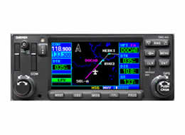
The GNC 420W adds a TSO-certified 760-channel comm transceiver to the GPS 400W's WAAS navigation capabilities and color display, creating the first color GPS/comm in the industry. GNC 420W has all of the IFR GPS and comm features of the GNS 430W minus the VOR, ILS or glideslope capability you may already have in your aircraft.
Save Space with Built-in Comm
The reliable GNC 420W delivers clear communication from its 10-watt, 760-channel VHF transceiver. In the alternative, GNC 420AW features a high power 16-watt transmitter for high altitude turbine aircraft. With the 420W's frequency nomination feature, you can easily load your next com frequency into standby with the touch of a button.
Fly WAAS Approaches
GNC 420W comes with built-in WAAS navigation capabilities. It is approved to fly LPV "glideslope" approaches without reference to ground-based navaids of any kind. Featuring an advanced 15-channel receiver capable of five position updates per second, GNC 420W meets the FAA's stringent TSO C146a standards for WAAS "sole means" navigation — providing vertical and lateral approach guidance into thousands of U.S. airports previously inaccessible in IFR conditions.
Get High-Resolution Mapping
GNC 420W's 4-inch high-contrast display with brilliant colors makes it easy to read and interpret pilot-critical information. Effective use of color makes it easy to see your position relative to ground features, chart data, navaids, flight plan routings, approach procedures and more. Conveniently scan information from wide viewing angles, even in direct sunlight.
Enhance Situational Awareness
GNC 420W seamlessly integrates built-in terrain and navigation databases, providing a clear, concise picture of where you are and where you're heading. The 420W's huge Jeppesen® database, updated with front-loading data cards, contains location reference for all airports, VORs, NDBs, Intersections, Flight Service Stations, published approaches, SIDs/STARs, Special Use Airspace and geopolitical boundaries. A detailed basemap clearly shows airports, cities, highways, railroads, rivers, lakes, coastlines and more. Using information from the built-in terrain and U.S. obstacles databases, the 420W displays color coding to graphically alert you when proximity conflicts loom ahead.
Expand Your Panel Mount
GNC 420W is easy to interface with a wide array of optional sensors and tracking systems, allowing you to see and avoid hazards such as threatening weather, lightning or air traffic. With an optional subscription to XM WX Satellite Weather™ and the addition of the GDL 69 or 69A datalink receiver, you'll have access to up-to-the-minute, high resolution weather for the U.S., right in the cockpit. Information includes NEXRAD, METARs, TAFs, lightning and more and can be laid directly over Jeppesen and topographic map databases. With an additional monthly service fee, GDL 69A delivers XM Satellite Radio to your aircraft. Add the Garmin GTX 330 Mode S transponder, and GNC 420W will also display Traffic Information Services (TIS) alerts that identify surrounding air traffic.
GNC 420W: Big-picture situational awareness
Spec Sheet
Feature Changes for Software Version 3.00
Garmin Opt Displays Pilots Guide Addendum
Non-Garmin Displays Pilots Guide
Pilot Guide and Reference
Quick Reference
WFDE Prediction Program Instructions
Related Manuals
Garmin GNS 430W GPS Navigator
Garmin GPS 400W GPS Receiver
Garmin GNC 300XL TSO GPS Navigator
Garmin GNC 250XL GPS Navigator
Garmin GPS 165 TSO GPS Receiver
Garmin GPS 155XL TSO GPS Receiver
Garmin GPS 150XL GPS Receiver
Garmin G600 Multi-Function Display
Garmin GMX 200 Multi-Function Display
Garmin GWX 68 Digital Color Radar
Garmin SL30 Nav/Comm Transceiver
Garmin SL40 Nav/Comm Transceiver