Garmin Colorado 400c Handheld Navigator
Garmin Updated: 2008-09-16 RSS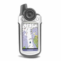
Whether you're sailing the high seas or hiking the backcountry, Colorado 400c is your all-in-one adventure guide. Preloaded with BlueChart® g2 coastal charts, Colorado is made with the saltwater mariner in mind. Packed with features, it includes a high-sensitivity receiver, barometric altimeter, electronic compass, SD™ card slot, color display, picture viewer and more. Even exchange tracks, waypoints, routes and geocaches wirelessly between similar units. When the going gets tough, Colorado leads the way.
Explore Coastal Waters
Colorado comes with built-in BlueChart® g2 coastal charts and a worldwide basemap with imagery — perfect for all your outdoor pursuits. Map detail includes includes shorelines, depth contours, navaids, harbors, marinas, port plans coastal roads for the U.S. and Bahamas.
Share Wirelessly
With Colorado 400c you can share your waypoints, tracks, routes and geocaches wirelessly with other Colorado users. Now you can send your favorite route to your buddy to enjoy or the location of a cache to find. Sharing data is easy. Just select "send" to transfer your information to other Colorado units.
Rock on. Find Fun
Intuitive and fun, Colorado features a Rock 'n Roller™ input wheel for easy one-handed operation and supports Geocaching.com GPX files for downloading geocaches and detail straight to your unit. Customize Colorado's interface based on your favorite activity. Even show off photos of your excursions with its picture viewer. Slim, lightweight and waterproof, Colorado is the perfect companion for all your outdoor pursuits.
Keep Your Fix
With its high-sensitivity, WAAS-enabled GPS receiver, Colorado 400c locates your position quickly and precisely and maintains its GPS location in the harshest marine environments. The advantage is clear — whether you're sailing the high seas, in dense tree cover or near tall buildings — you can count on Colorado to help you find your way when you need it the most.
Get Your Bearings
Colorado 400c has a built-in electronic compass that provides bearing information even while you're standing still, and its barometric altimeter tracks changes in pressure to pinpoint your precise altitude. You can even use the altimeter to plot barometric pressure over time, which can help you keep an eye on changing weather conditions.
Plug in and Go
Conveniently plug in optional preloaded SD cards for all your outdoor activities on land or water. Just insert a MapSource card with detailed street maps, and Colorado provides turn-by-turn directions to your destination. Add select topographic maps to take advantage of Colorado's 3-D map view which gives you a better perspective of your elevation. The card slot is located inside the waterproof battery compartment, so you don't have to worry about getting it wet.
Colorado 400c: For adventure in any direction.
Owners Manual
Quick Start Guide
Related Manuals
Garmin Colorado 300 Handheld Navigator
Garmin Colorado 400i Handheld Navigator
Garmin Colorado 400t Mapping Handheld Navigator
Garmin eTrex Legend Handheld Navigator
Garmin eTrex Legend HCx Handheld Navigator
Garmin eTrex Summit HC Handheld Navigator
Garmin eTrex Venture HC Handheld Navigator
Garmin eTrex Vista Handheld Navigator
Garmin eTrex Vista HCx Handheld Navigator
Garmin GPSMAP 60 Mapping GPS Receiver
Garmin GPSMAP 60Cx Mapping GPS Receiver
Garmin GPSMAP 60CSx Mapping GPS Receiver